Shawangunk Grit
An Epic Gravel Ride on the Shawangunk Ridge to Benefit Mohonk Preserve
Course Description
Pick from two distances: 50.4 miles (4,711 ft gain) or 23 miles (1,895 ft gain). Both courses begin and end at the Ulster County Fairgrounds and once you enter the Preserve at mile two, the course is 99% gravel on our famous network of carriage roads.
50.4 Mile
23 Mile New course for 2025!
Old Pasture Loop Bypass (49.5 miles) bypasses a majority of technical single-track on the 50.4 mile course. Follow course markings at mile 28 to use the bypass option if you’re not a fan of single-track.
The long course is for the serious cyclist and will feature an exclusive opportunity to ride up to Sky Top* the iconic tower on the Shawangunk Ridge. Opt for the short course if you are not an experienced gravel rider, especially with elevation gains. You’ll have a more enjoyable ride on the shorter course. Both routes promise epic climbs, satisfying descents, and amazing views.
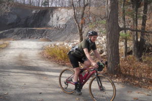
This is not a race; think of it as a super challenging fun ride for a really good cause. Some gravel is rough and steep. Expect loose rock – especially on the descents. The 50-mile course includes an optional single track section and a mandatory dismount/bike hike up cedar steps near the “Million Dollar View.” Bring your gravel, cyclocross, or mountain bike. Class 1 e-bikes are permitted if you can manage the technical sections. No road bikes, please.
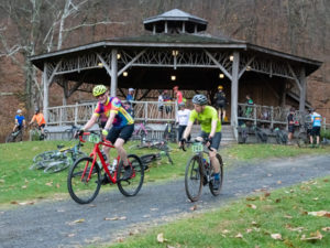
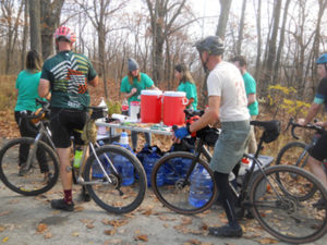
You won’t be timed but you will be well-fed. Look for three well-stocked aid stations and a post ride party at the fairgrounds where you will relax, listen to some music and share your course experience. Be sure to carry some food and water, and maybe extra clothes depending on the weather. You’ll be sharing the carriage roads with hikers and climbers, so bike bells are highly recommended. Pack a spare tube, tools, and pump as there’s no mechanical support on course and no sag wagon. Helmets are required.
Be prepared for a challenging, but fun ride!
*Shout out to our friends at Open Space Institute who granted us access to their section of the River-to-Ridge Trail and to Mohonk Mountain House who granted us access to Sky Top and the golf course area for the event day only. Bikes are not allowed on the carriage roads up to Sky Top so you cannot pre-ride this section of the course or the paths that traverse the golf course. No exceptions – If we blow this, access to Sky Top and the golf course will not continue. PLEASE DO NOT POST PICS FROM SKYTOP ON SOCIAL MEDIA PLATFORMS.
Also, near Spring Farm Trailhead, the private driveway near the Slingerland Pavilion, the Table Rocks Trail, and the Crag Trail on the Preserve are accessible to ride participants during the event only. You cannot pre-ride these sections.
Aid Stations: (subject to change)
50.4 Mile Course
Slingerland Pavilion at Spring Farm, mile 12.4
Home Farm Circle, mile 25
Welcome Boulder, mile 35.7
Gravel Yard, mile 43.1
23 Mile Course
Welcome Boulder, mile 9.6
Home Farm Circle, mile 13

Join our email list!
Cover photo by Renee Zernitsky