Take a Walk Back in Time
Along the Trapps Mountain Hamlet Path
Explore the traces of a 19th century mountaintop community by visiting the Trapps Mountain Hamlet Interpretive Path at the Mohonk Preserve or by taking a virtual tour right here on our website.
What is special about the Trapps Mountain Hamlet?
Once home to the huckleberry-pickers and stone-cutters of the past century, the Trapps Mountain Hamlet housed as many as 40-50 families by the time of the Civil War. This vanished hamlet now consists of the restored Van Leuven Cabin; 60 cellar holes and foundations of dwellings, mills, barns, a school, a tavern, a chapel, and other structures; over 40 charcoal pits; and four family burying grounds. This historic district is a subsistence hamlet listed on both the New York State and National Register of Historic Places.
To access this trail, park at the West Trapps Trailhead. Follow the blue markers for this 1½-mile, moderate walk along 12 stops of cultural history interest – uphill in places, not wheelchair accessible. Return by the same trail. Do not follow the highway.
Listen to the audio tour below, or click here to download the tour on iTunes.
Special thanks to the many people, including former residents of the Trapps Mountain Hamlet and descendants of Trapps families, who contributed their knowledge of life in the hamlet and family materials for this project and also to Christopher Boulton for his assistance in developing the audio portion of this tour.
The Trapps Mountain Hamlet Path was constructed by Ed Reppert, Coordinator of Volunteer Trailkeepers, with the assistance of Steve Sandberg, trail volunteer.
The text was adapted from the original “Trapps Mountain Hamlet Guide” written by Bob Larsen and edited by Robi Josephson.
Stop 1: “Boulder Pile in Old Pasture”
Even when cleared of trees, the relatively thin soil, with many rocks and boulders jutting up, provided only marginal pastureland able to support just a few farm animals. In order to maximize the amount of area for grass growth, most of the early farmers removed as many rocks as possible from the soil.
But where to put the rocks? Some were used to build the low stone boundary walls so characteristic of New York and New England. It was also common for farmers to simply collect any rocks that could be moved and pile them on top of an especially large (and immovable) boulder or a bedrock outcrop.
Stop 2: “Millstone Cutting”
Here you will see a large, rounded piece of Shawangunk Conglomerate (sometimes called Shawangunk Grit) that a millstone cutter abandoned long ago. In some parts of the Shawangunks, ready access to more suitable exposures of the conglomerate bedrock made it possible to produce excellent, readily-saleable gristmill stones, an important source of income for Trapps families in the 19th century.
Stop 3: “The Old Bridge”
Here, the trail crosses a brook located at a point where a farm wagon road once crossed the stream. Its existence is indicated by a number of stones laid on top of one another on each side of the brook to form bridge abutments. The bridge would have allowed the passage of wagons carrying hay, firewood, or cut millstones
Stop 4: “Crossing the Stone Boundary Fence”
Here the trail crosses over an old stone fence, leaving one property and entering onto another. The lands ahead belonged to Ben Fowler who owned about 150 acres. The New York State Agricultural Census of 1865 recorded 29 acres in pasture, 38 acres in meadow for hay making, 2 acres in winter rye, 4 acres in oats, and 8 acres in buckwheat. The census also listed his livestock as consisting of three horses, four pigs, 24 sheep, and a flock of chickens. For the most part, the Trapps Hamlet economy was one of subsistence farming, with most residents owning a few horses, cows, pigs, and a flock of chickens.
Stop 5: “The Old Turnpike”
Just ahead is Trapps Road, an automobile road that was laid down on top of a much older road called the Wawarsing-New Paltz Turnpike. The turnpike was originally built in 1856 as a toll route over the mountain between the Wallkill Valley (New Paltz) and the upper Rondout Valley (Wawarsing-Ellenville). Tolls were collected on the Trapps Ridge at the gap now spanned by the Trapps Bridge that crosses over Route 44/55, one-half mile east of the West Trapps Trailhead. After a few years as a toll road, the turnpike went bankrupt and became a public road. Travelers were able to spend the night at Ben Fowler’s lodging house and tavern, located a hundred yards up the turnpike to the south. All that remains of the tavern today is a large cellar hole.
Stop 6: “Old Van Leuven Road”
Shortly after crossing the auto road, you turn left and enter onto an old dirt road. This road was an early track leading to the pioneer Van Leuven homestead about 1½ miles away on the west side of Millbrook Mountain. (The homestead is presently on the Preserve’s Coxing Trail, which follows, in part, the Van Leuven Road). Later this track became a Gardiner town road, well-traveled by pedestrians, horseback riders, horse-drawn wagons, and even an early Ford or two, before the road fell into disuse.
Stop 7: “Coxing Kill”
Here you can see the Coxing Kill flowing over conglomerate outcrops amid large boulders. The Coxing is a major stream flowing down from Lake Minnewaska two miles upstream from here. It flows out through the Trapps Hamlet and the Clove, where it can be seen along Clove Road and again at the Enderly Mill site. In Dutch, the word “kill” means river or stream; the word “clove” refers to a deep, mountain valley. The Coxing Kill was the chief source of water for the people in the area. About a mile downstream at Split Rock (Coxing Trailhead) was a water-powered sawmill, called the Enderly Mill, which produced many of the boards and beams used in the construction of the Trapps Mountain Hamlet houses.
Stop 8: “Fowler Burial Ground”
Here is one of the several family burying grounds established by the people of the Trapps Mountain Hamlet as an alternative to public cemeteries. The oldest headstone to be recognized here dates from 1866. One of the old stones is that of Ben Fowler, landowner and the proprietor of the nearby lodging house and tavern. A number of the burials here were of the infant children of George and Rachel Coddington, another of the Trapps families. Rachel was a daughter of Ben Fowler.
Stop 9: “An Overgrown Road”
Look up the Old Van Leuven Road, now cutting through dense forest, and try to imagine the scene a century ago when the area was open to the skies and the road was bordered by almost entirely cleared fields of crops and by pastures with grazing animals. Far ahead, the Eli Van Leuven home would have been visible, as well as various outbuildings.
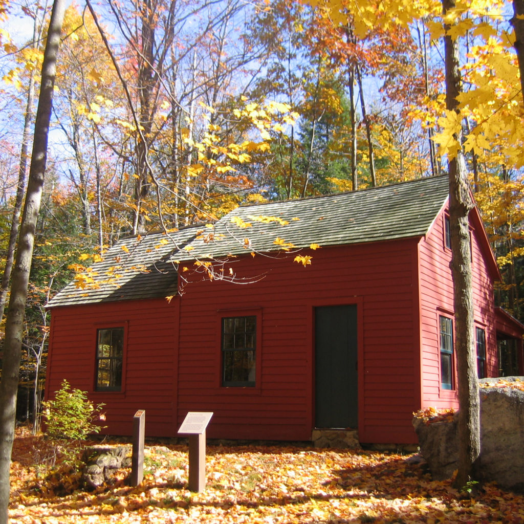
Stop 10: “Eli Van Leuven Cabin”
Here is one of the few remaining homes of the nearly vanished Trapps Mountain Hamlet. Its small size and simple, unadorned lines were typical of the Hamlet. The cabin is a plank house built in 1889 or 1890 by William Hagen and bought by Eli Van Leuven in 1898. Eli’s family occupied the house into the 1920s when the Mohonk Mountain House bought the property.
What was family life in the Trapps like during the late 1800s? A typical family was large, with many children all living in a house as small as the one you see here. Trapps men worked at a variety of jobs, including stone-cutting, charcoal-burning, cutting cord wood, and shaping hoops for barrels; they worked, too, as day laborers for the Minnewaska and Mohonk Mountain Houses. Trapps women also worked at a variety of occupations, both at home and at the local mountain hotels. At home, they made butter and cheese, raised chickens, and cultivated kitchen gardens with the help of the children. Some women had hand looms on which they wove a variety of fabrics. Summertime blueberry- and huckleberry-picking was an activity for the entire family, with the sale of berries being another source of cash.
Like most Trapps houses, the Van Leuven Cabin lacked plumbing of any kind. There was no electricity, so candles and kerosene lamps were used when required. Electric and telephone lines did not reach parts of the Trapps Mountain Hamlet until the 1950s or later! In the photo, we can see how the Van Leuvens made use of the large boulder located next to their home. Using millstone-cutting methods, a large, crude shelf was fashioned, thereby producing a useful, outdoor, working surface for washing and cooking.
Stop 11: “Path to Spring Run”
The family of Eli Van Leuven evidently never dug a well. Instead, they depended for their drinking water on a spring located down slope from their house adjacent to the Coxing Kill (into which the spring water flows). The path to this water source descends sharply downhill and requires a steep uphill return.
One of the Van Leuven children’s chores was hauling water uphill to the house. At the stream, the water flows between smooth ledges of bedrock, and well-placed stones provided convenient perches for bathing and clothes washing. Imagine what it was like to get water to bathe and wash clothes in icy winters!
Stop 12: “Site of the Coddington House”
In 1874, George Coddington acquired land from a member of another old-time Trapps family, the Burgers, and built a house here. The depression in the ground is all that remains of the cellar of the house. As with most structures in the Trapps Mountain Hamlet, the upper, wooden portion of the house has long disappeared. Just beyond this house site lies U.S. Route 44/55, which was completed in 1930. Keep in mind that for most of the existence of the Trapps Mountain Hamlet, this highway was not here! The building of this road provided work for years for a number of Trapps men, but, ironically, its route destroyed many of the homesteads in the Trapps Mountain Hamlet.
Banner photo by Bob Fisher